{Added later. There is now a “Region-talk postings” Page under “Linguistics notes”.]
In my posting of the 29th on “The greater West Coast area” (or region), I confronted some of the issues surrounding region-talk, in which people struggle to give names to geographical areas that have some importance in their lives but no standard names — areas that are bigger than named governmental units (Chicagoland, greater Chicago, the Chicago area) or ones that are smaller (southern California, northern California, the Central Coast (of California)). These labels are invariably fuzzy in actual use, with unclear boundaries and variation between users (though they are often precisified for administrative or official purposes).
Now, some further remarks on the greater West Coast area/region; on the Deep South as a region of the U.S. (significant as the presidential primary elections wind on in my country — cf. the South, the Midwest, etc.); and a reference to Northeast Asia (cf. East Asia, Southeast Asia, South Asia) that I came across some time ago.
The greater West Coast. The motivation for the greater West Coast area was to extend the range of events that a Bay Area shapenote mailing list could list, as a service to local singers who might want to take part in singings. Mostly these singings are up and down California, but some are in Washington and Oregon. And then one came up in Arizona (beyond the states actually on the West Coast, WA OR CA). It’s a matter of distance (given here according to straight-line routes, all somewhat longer as driving distances):
San Francisco to Seattle: 679 miles
San Francisco to Phoenix: 653 miles
San Francisco to Tucson: 755 miles
Events in AZ are then roughly as far away as those in WA. (If you’re in SoCal, closer.)
In that earlier posting, I reported on a company based in Sacramento that had a service area, called the greater West Coast region, based on distance: WA OR CA, plus NV UT AZ.
None of these greater West Coasts are much in the way of culture zones. In all of WA OR CA, there’s a big cultural divide between the western, coastal strips and the eastern, inland areas, a divide that this greater West Coast terminology ignores. But it all deoends on what you want the terminology for.
In addition, the west coast of the U.S. includes AK, but that’s discontinuous from WA — BC intervenes — and it’s culturally distinct from the west coast of the contiguous 48. The west coast of North America takes in BC and AK, but also Baja California and, along the Gulf of California and south of it, a huge stretch of Pacific coast, taking in a number of states and vacation cites like Mazatlán, Puerto Vallarta, and Acapulco, and on south to the Guatemalan border. Nobody seems to think of the west coast of the continent north of Mexico as a coherent cultural zone, and no one thinks of Mexico as in a culture zone along with the coastal region north of it.
There might be cruise companies that think of the Pacific coast from Acapulco to Juneau as a conceptual unit, but I haven’t found evidence of this.
The Deep South. I lead with a map from Wikipedia:
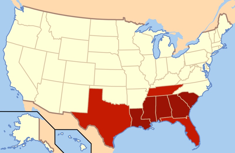 (#1)
(#1)
The states in dark red compose the Deep South today. Adjoining areas of East Texas, West Tennessee, and North Florida are also considered part of this subregion. Historically, [all] of these states were in the Confederate States of America.
From the article:
The Deep South is a descriptive category of the cultural and geographic subregions in the Southern United States. Historically, it is differentiated from the “Upper South” as being the states most dependent on plantation-type agriculture and slavery during the pre–Civil War period. The Deep South was also commonly referred to as the Lower South or the Cotton States. Before the out-migrations at the first half of the 20th century, African-descended peoples comprised the majority of the population in numerous areas and some states. Today, the Deep South is usually delineated as being those states and areas where cultural elements most often thought of as “Southern” exist in their most concentrated form.
In all of this, New Orleans and the bayou country of southern Louisiana is a distinct culture zone from the rest of the state.
Three somewhat different ways of delineating the Deep South:
– Most definitions include the states Georgia, Alabama, South Carolina, Mississippi, and Louisiana. Arkansas is sometimes included or else considered “in the Peripheral or Rim South rather than the Deep South.”
– The seven states that seceded from the United States before the firing on Fort Sumter and the start of the American Civil War and originally formed the Confederate States of America. In order of secession they are: South Carolina, Mississippi, Florida, Alabama, Georgia, Louisiana, and Texas. The first six states were those that held the largest number of slaves.
– A large part of the original “Cotton Belt”, generally extending from eastern North Carolina to South Carolina and through the Gulf States as far west as East Texas, and including those parts of western Tennessee and eastern Arkansas in the Mississippi embayment. [flat country characterized by rich alluvial soils, heat and humidity]
For whites, the Deep South is now strongly conservative Republican. And, again for whites, people of English ancestry traditionally (and strongly) predominate in every part of the Deep South except for southern Louisiana.
Northeast Asia. A map for reference:
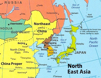 (#2)
(#2)
From the Wikipedia article, which rightly stresses differences in the way the region is delineated, according to the purposes the term is to be used for:
The definition of Northeast Asia (though often used interchangeably with East Asia, but not always necessarily [in an exact] correspondence) is not static, but often changes according to the context in which it is discussed.
In geopolitics, the Council on Foreign Relations defines Northeast Asia as Japan, North Korea, and South Korea. China and Russia are often included in geopolitical discussion of the region to the extent their interests and policies interact with those of Japan and [the] Koreas. The East Sea, the Yellow Sea, and sometimes the East China Sea and the Sea of Okhotsk are included in discussions of the region.
In common usage, however, the term Northeast Asia typically includes China. In this form, the core countries constituting Northeast Asia are China, Japan, North Korea, and South Korea.
The Economic Research Institute for Northeast Asia defines the region as consisting of “China, Japan, the Koreas, Mongolia, and eastern regions of the Russian Federation.” The World Bank refers to the “three major Northeast Asian economies, i.e. China, Japan, and South Korea”, and also acknowledges a broader definition that embraces China (including Hong Kong, Macau and Taiwan), Japan, the Koreas, Mongolia, and the Russian Far East and Siberia.
In biogeography, Northeast Asia generally refers to roughly the area spanning Japan, the Korean Peninsula, Northeast China, and the Russian Far East between Lake Baikal in Central Siberia and the Pacific Ocean.
In the last view, we have areas oriented towards the Pacific Ocean, subject to regular snows, and populated by characteristic plants and animals.
March 3, 2016 at 11:47 am |
[…] Zwicky considers a variety of geographic areas with indeterminate boundaries, like the South and northeast […]