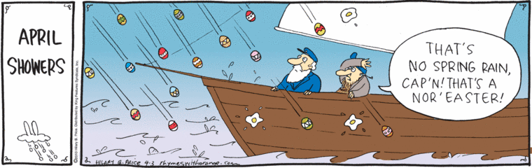
Hilary Price’s Rhymes With Orange with a seasonal strip:
ADS-L had an extended discussion of Northeaster/Nor’easter back in January. The expressions go back to 18th century America, with the first somewhat older than the second (not surprisingly). Some sources have them just referring to a strong wind from the northeast, but many commenters understand them as referring to the accompanying storm of rain, sleet, snow, etc. — specifically on the eastern coast of North America, roughly from New York through the Maritimes.
These storms are low-pressure systems, with the associated winds moving circularly from a low-pressure front to higher-pressure areas, so the winds in the classic nor’easter come from the northeast. (This can be confusing, because the storm itself is moving from south to north.)
There are other northeasterly winds — the Diablo winds of the San Francisco Bay area, for instance. And the Santa Ana winds of southern California are usually northeasterly.
Meanwhile, back on ADS-L, on 19 January Kelli Slimp reported Blue Norther from West Texas, for a ferocious winter storm accompanying a cold front from Canada (that is, coming from the northwest, rather than from the southwest, as in the classic Atlantic nor’easter), and others seconded this usage, which got some degree of fame from Ian Tyson’s song “Someday Soon”, with its lines:
So blow, you old Blue Northern, blow my love to me
He’s ridin’ in tonight from California
Well, that’s the way it appears on lyrics on the net, and that’s the way it’s sung on some recordings (the Ian and Sylvia version I have on my iTunes, for instance), but other recordings have Blue Norther, and many people feel strongly that that’s the way it ought to be sung.
No reported sightings of Nor-easters (or Blue Northers) with rains of Easter eggs, however, though that would look festive, while probably being as damaging as hail.
April 4, 2010 at 7:50 pm |
with the associated winds moving circularly from a low-pressure front to higher-pressure areas,
The pressure is caused by the winds, rather than vice versa.
Counter-clockwise winds around a low pressure area are trying to turn right and escape, and are held back by the low pressure at the center, having escaped as far as they can.
If the winds headed into the low pressure, the low pressure would disappear very fast.
Ground level winds do head into the low pressure, running at about 45 dgrees to the higher winds, as they are slowed by the ground; which quickly gives the “eye” of the low some rising air. If in addition it’s moist air, there’s a nice heat engine formed when it condenses while rising. Hence the rain if not worse.
What kills low pressure areas most quickly is running into another low pressure area, because wind hits opposing winds, goes turbulent and stops.